Provinces
Counties
Blekinge
Dalarna
Gotland
Halland
Jönköping
Kalmar
Kronoberg
Norrbotten
Skĺne
Stockholm
Södermanland
Uppsala
Värmland
Västmanland
Västra Götaland
Örebro
Östergötland
Other stuff
Home

|
|
County of Norrbotten: Kebnekaise - 2111 m
|
Location: West of Kiruna
Coordinates:N 67°54.054' E 18°31.041'
Exact height: 2111 m
Hiking: Class 1 (What's this?)
Hiking distance: 62 km round trip
Elevation gain: ~ 1850 m
Maps:
Topographic: Fjällkartan BD6 or BD8,
Högfjällskartan Kebnekaise
Road map: Any road map
All maps from Lantmäteriet
|
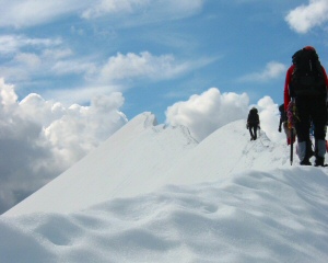
Click in the picture to see more pictures.
|
Approach:
Use bus 92 from Kiruna to Nikkaluokta. The ride is about one hour. There are several possibilities
to go from Nikkaluokta to the Kebnekaise Mountain Lodge. The price differs between the alternatives
but any of them takes you 230 m higher (prices are from summer 2005):
1. Hiking, 19 km along a trail
2. Hiking and boat, 13 + 6 km, SEK 140, one way, and SEK 200, return ticket
3. Helicopter, SEK 500, one way
Route:
Western route (Class 1)
Use the route information available in the mountain lodge. The Western route is about 24 km
and the altitude gain is 1620 m.
Eastern route (Class 4)
Use the route information available in the mountain lodge. There are guided tours
available for the Eastern route as it crosses glaciers and also contains a bit of
easy rock climbing. These sections are traversed with the group roped up. The
Eastern route is about 14 km and the altitude gain is 1420 m.
Route from the Tarfala Hut (Class 4 + steep snow and ice)
Hike the trail from the mountain lodge to the Tarfala Hut, about 7 km. Spend the
night in the hut and rest. Cross the Tarfala creek and hike up and across the
Isfall glacier to the bottom of Hals pass. Climb the steep snow field to the
pass. Be careful when crossing the bergschrund in the lower part of the snow field.
Continue south from the pass, rock climbing following a traditional route with
fixed protection. Hike up and across the snow field to the Northern summit.
Follow the knife edge ridge to the Southern summit - the highest point in Sweden.
Continue South across the summit plateau to the old top hut. Follow the Eastern
route down the face to the ridge of Björling's glacier. Cross the glacier to the
pass to the Stor glacier at Nygren's route. Follow the Stor glacier back to the
Tarfala creek and back to the Tarfala Hut. This route is about 14 km and has a gain
of about 1100 m. We have made a
map for this route.
Links:
The Kebnekaise Mountain lodge is busy during the summer. Make sure to reserve a bed
in advance and charge the batteries for the summit attempt. Information on the
different routes and other things to do at the lodge is available at the web site
of the Swedish Touring Club,
STF.
More information on Kebnekaise is available in Swedish at
kebnekaise.nu.
|
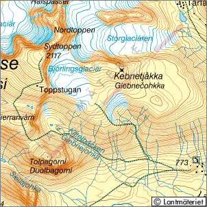
Click in the map to get a larger map!!
|
|
