
Provinces
Counties
Blekinge
Dalarna
Gotland
Halland
Jönköping
Kalmar
Kronoberg
Norrbotten
Skĺne
Stockholm
Södermanland
Uppsala
Värmland
Västmanland
Västra Götaland
Örebro
Östergötland
Other stuff
Home
| Västmanland: Timmerĺsarna - 331m | |
|---|---|
|
Location: Northwest of Skinnskatteberg Coordinates: N 59°52.984' E 15°27.589' Approx. height: 331 m Hiking: Class 1 (What's this?) Hiking distance: 1,4 km round trip Elevation Gain: 31 m Map(s): Topographic: 11F NO Lindesberg Road map: 114 Lindesberg, or any road atlas All maps from Lantmäteriet |
 Click image to see more photo's |
Approach:
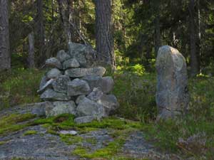
From Skinnskatteberg drive northwest on Rt. 233 for approx. 14.9 km. (If approaching the farm at Plöjningen, turn around and go back approx 0.9 km.) Turn left onto a gravel road. Continue on this road for 2.2 km to an intersection. Keep left. Continue 0.9 km and then keep right onto a smaller gravel road. Continue another 2.5 km and keep right again onto an even small dirt road. It has lots of grass in the middle of the road, but, as far as we know there are no rocks hitten. (We made it without any problems with a quite low SAAB 9-3, so almost any car is suitable.) Continue with caution on this road for another 1.5 km until the road suddenly turns into a grassy dirt road and almost vanishes. This is an open area, big enought to turn around and park a couple of cars.Route: There is no trail to the summit, so make sure to bring a topo map. From the parking area hike west on the overgrown dirt road for about 100 m. From here take a bearing to the summit and start to bush wack. Pass over 4 - 5 ditches and then start to climb the hill. The dense forest thinnens a bit as you approach the summit. There is a cairn and a rock block marking the highpoint. (When we visited, in August 2003, we found blue blazes which took us to the top of the ridge, just a bit north of the actual highpoint. Follow these if found, they make life easier.) | |
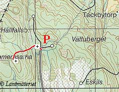 Click for larger map! |
|