
Provinces
Counties
Blekinge
Dalarna
Gotland
Halland
Jönköping
Kalmar
Kronoberg
Norrbotten
Skċne
Stockholm
Södermanland
Uppsala
Värmland
Västmanland
Västra Götaland
Örebro
Östergötland
Other stuff
Home
| Skċne: Magleröd - 212 m | |
|---|---|
|
Location: Westsouthwest of Ljungbyhed Coordinates: N 56°03.912' E 13°08.295' Exact height: 212 m Hiking: Class 1 (What's this?) Hiking distance: 0.4 km roundtrip Elevation gain: < 10 m Maps: Topographic: 3C SO Helsingborg Road map: Any road map All maps from Lantmäteriet |
 Click in the picture to see a larger version. Note that the map gives the altitude 209.5 m for Magleröd and that the hill Höjehall not far from Magleröd is 209.7 m. Our contact person at the Geographical Survey extracted 212 m from their database though. |
Approach:
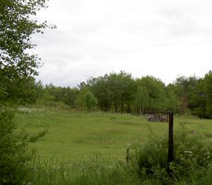
Drive from Svalöv to Kċgeröd and further on to Stenestad along the road that crosses Söderċsen towards Klippan. Turn right (east) on the right (southern) road, in Gċlarp, a bit less than 2 km northeast from the intersection in Stenestad. Continue towards Magleröds Gċrd. Park along the road or on the driveway to the right after 1.4 km.Route: The highpoint is about 200 m on the left (northen) side of the road, on a small hill, in the corner of a field. A triangle mark should mark the summit.Other: We did not find the triangle mark but a sign on the highpoint told us we were on the right spot. |
|
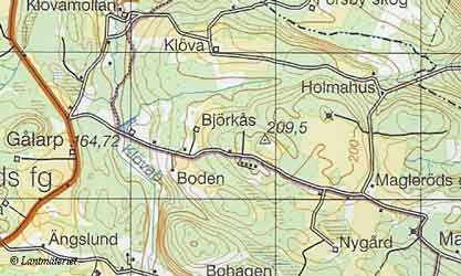 Click in the map to get a larger map!! |
|