
Provinces
Counties
Blekinge
Dalarna
Gotland
Halland
Jönköping
Kalmar
Kronoberg
Norrbotten
Skĺne
Stockholm
Södermanland
Uppsala
Värmland
Västmanland
Västra Götaland
Örebro
Östergötland
Other stuff
Home
| Uppsala: Hjortmosseberget - 112 m | |
|---|---|
|
Location: ENE Heby Coordinates: N 59°58.891 E 17°05.177' Exact height: 112 m Hiking: Class 1 (What's this?) Hiking distance: 0.7 km round trip Elevation gain: Approx. 10 m Map(s): Topographic: 12H SV Road map: Any road map All maps from Lantmäteriet |
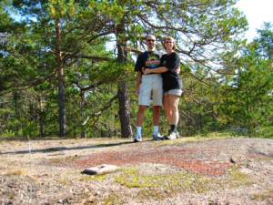 Click in picture to see more photos! |
Approach:
Start from the Inn at Rt 72 in central Heby. Reset the trip computer. Drive north in direction "Centrum". Pass the railroad after about 700m and turn right in direction Huddunge. After 3.8 km, turn right in direction Molnebo. In Molnebo, after 6.6 km, turn right again, in direction Östfora. The border to Uppsala county is passed afterRoute: Follow the dirt road, in direction NW, for less than 400 m to a big flat stone area. The highpoint is located straight ahead, close to the old concrete foundation.Comment: The highpoint of the province of Uppland is located about 1 km south of this highpoint and is inviting to a double, in the same day. |
|
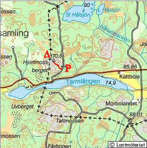 Click in the map to get a larger map!! |
|