
Provinces
Counties
Blekinge
Dalarna
Gotland
Halland
J—nk—ping
Kalmar
Kronoberg
Norrbotten
SkÍne
Stockholm
S—dermanland
Uppsala
Vðrmland
Vðstmanland
Vðstra G—taland
ørebro
østerg—tland
Other stuff
Home
| ørebro: Svinh—jden - 436 m | |
|---|---|
|
Location: 10 km SSW Gravendal Coordinates: N 59°59.482' E 14°28.150' Approx. height: 436 m Hiking: Class 1 (What's this?) Hiking distance: 1.2 km round trip Elevation Gain: 86 m Map(s): Topographic: 12E SO Sðfsnðs Road map: 123 Sðfsnðs All maps from Lantmðteriet |
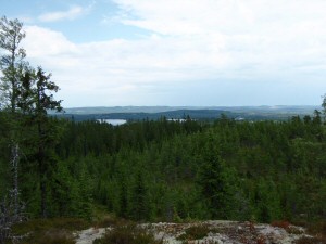 Click image to see more photo's |
Approach:
1. From route 63 in Hðllefors, drive towards town center along the northern main street. Cross the railroad, turn right and drive north to Sðvsj—n, about 15 km. Turn left and continue north about 11.5 km to St. Tornsj—n. Turn left on a dirtroad and then left again after about 250 m. Continue to road's end, appr. 750 m, and park. 2. From Grðngesberg, drive south on route 60. About 4.5 km south of the railroad bridge, in Silverh—jden, turn right towards Yxsj—berg. Drive west to Yxsj—berg, appr. 14.7 km, and continue to Gravendal, an additional 21.4 km. Continue south of lake Skðrsj—n in Gravendal towards M—rttjðrn and then towards Sðvsj—n. About 10 km from Gravendal, in St. Tornsj—n, turn right to a dirtroad and then left after appr. 250 m. Continue to road's end, appr. 750 m, and park.Route: Hike up the hill along the northern edge of the clear-cut area. Continue upwards when in the woods. There are large boulders spread around the summit and an old shred has collapsed on the summit. Somewhere in the moss there is a triangle mark. |
|
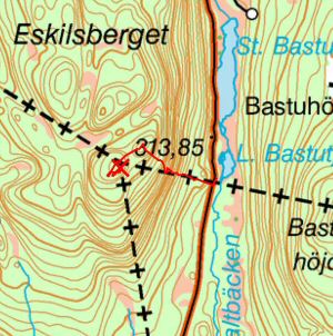 Click for larger map! |
|