Provinces
Counties
Blekinge
Dalarna
Gotland
Halland
Jˆnkˆping
Kalmar
Kronoberg
Norrbotten
SkÂne
Stockholm
Sˆdermanland
Uppsala
V‰rmland
V‰stmanland
V‰stra Gˆtaland
÷rebro
÷stergˆtland
Other stuff
Home

|
|
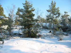
Stockholm: St Tornberget - 111 m
|
Location: West of V‰sterhaninge
Coordinates: N 59°08,215 E 18°00,965'
Exact height: 111 m
Hiking: Class 1 (What's this?)
Hiking distance:
Main route: 4 km round trip
Alternative route: 5 km round trip
Elevation gain: Approx. 50 m
Map(s):
Topographic: 10I SO
Road map: Any road map
All maps from Lantm‰teriet
|
Click in picture to see more photos!
|
Approach:
Main route:
Drive mainly west on Rt. 257. From the 90-degree curve in Tungelsta it is approx. 4.6 km until you should leave the main road. Pass the turn-off for Pr‰st‰ngen and also the one to Wedan. Take the next gravel road to the right (north) and continue about 550 m. Park close to the intersection with a small dirt road with a [sometime closed] gate. This location is marked with a "P" in the map below.
Alternative route:
From Rt. 73 south from Stockholm and Handen, take Rt. 259 towards Huddinge. After approx. 7 km make a left in Ekedal, towards Paradiset (The Paradise). Continue another 3.5 km until you reach Paradiset and park here. See also Fˆreningen Paradiset Hanvedens v‰nner only in Swedish.
Route:
Main route:
Hike on the small dirt road to the right and past the gate. After about 400 m, another dirt road heads off to the right, stay straight here for another 300 m. Look for a trail in the woods on the right hand side. It is marked with white and green square markers. Stay on this trail for about 1.1 km until you reach the summit of St Tornberget. At this point, the trail merges with Sˆrmlandsleden, which is marked with orange markers.
Alternative route:
From the parking lot in Paradiset follow Sˆrmlandsleden south to the summit of St Tornberget. This part of Sˆrmlandsleden is called section 5.3.
Links:
The highpoint of Stockholms County is located in
Hanvedens nature reserve.
The alternate route, described above, uses section 5.3 of
Sˆrmlandsleden from Paradiset.
On a
trail map
St Tornberget is found in the lower left corner.
|
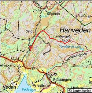
Click to get a larger map!!
|
|
