
Provinces
Blekinge
Bohuslðn
Dalarna
Dalsland
Gotland
Halland
Lappland
Nðrke
SkÍne
SmÍland
S—dermanland
Uppland
Vðrmland
Vðsterg—tland
Vðstmanland
øland
østerg—tland
Counties
Other stuff
Home
| Bohuslðn: Bj—rner—dspiggen - 222 m | |
|---|---|
|
Location: Eastnortheast of Str—mstad Coordinates: N 59°00.758' E 11°24.171' Exact height: 222 m Hiking: Class 1 (What's this?) Hiking distance: 3 km round trip Elevation gain: Approx. 120 m Map(s): Topographic: 10A SO Road map: Any road map All maps from Lantmðteriet |
We haven't been to Bj—rner—dspiggen sofar and we are happy and thankful receivers, should anyone want to submit information. |
Approach:
From Rt E6 in Skee Ún northern Bohuslðn, follow signs to Krokstrand and Bj—rner—d. Park according to signs where the hiking trail Bohusleden crosses the road in Bj—rner—d.Route: Hike steeply uphill along the trail Bohusleden from Bj—rner—d to the top of Bj—rner—dspiggen. There is a lookout tower on top of the highpoint. Hike the same way back to the parking. | |
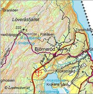 Click in the map to get a larger map!! |
|