
Provinces
Blekinge
Bohuslän
Dalarna
Dalsland
Gotland
Halland
Lappland
Närke
Skĺne
Smĺland
Södermanland
Uppland
Värmland
Västergötland
Västmanland
Öland
Östergötland
Counties
Other stuff
Home
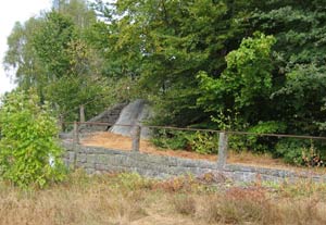
| Blekinge: Boafallsbacke - 180m | |
|---|---|
|
Location: in western Blekinge, outside Jämshög Coordinates: N 56°14,251' E 14°28,298' Exact height: 180 m Hiking: –, Drive-up Hiking distance: – Elevation Gain: NA Map(s): Topographic: 3E NV Karlshamn Road map: 33 Kristianstad All maps from Lantmäteriet |
 Click image to see larger photo |
Approach:
From Pukavik, in south western Blekinge, take Rt. 121 towards Jämshög for about 13 km. In Jämshög you have to find the main road going west. To find it, start by finding the church, go about 100m north and then head west wards. Now, stay on this road approx. 4,3 km before turning left on a narrow gravel road. Drive about 0,3 km and park infront of an outhouse. Please be curteous, this is somebodys summer cottage. If they are currently staying in the cottage, pass it and park further up the road. (There is a intersection where it is possible to turn around.)Route: The high point is 20 m south of the outhouse. There is a triangle mark on the summit. |
|
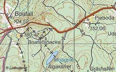 Click in the map to get a larger map! |
|