
Provinces
Blekinge
Bohuslän
Dalarna
Dalsland
Gotland
Halland
Lappland
Närke
Skĺne
Smĺland
Södermanland
Uppland
Värmland
Västergötland
Västmanland
Öland
Östergötland
Counties
Other stuff
Home
| Dalecarlia: Storvätteshĺgna - 1204 m | |
|---|---|
|
Location: ENE Grövelsjön Coordinates: N 62°07.244' E 12°27.080' Exact height: 1204 m Hiking: Class 1 (What's this?) Hiking distance: ~18 km roundtrip Elevation gain: ~400 m Maps: Topographic: 162C Grövelsjön Road map: Any road map All maps from Lantmäteriet |
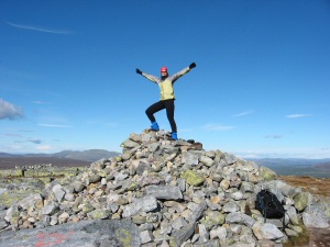 Click in the picture to see more pictures. |
Approach:
Drive Rt 70 to Idre and continue about 38 km to Grövelsjön. At the Sjöstugan intersection, just before the Mountain Lodge, turn right to a gravel road. Drive about 300 m uphill to a gravel parking on the left and park. There is a trailhead at the parking.Route: The trail starts out as gravel but changes to a normal rocky mountain trail after a while. Follow the blazed trail for about 9 km over a hill, across a bridge and up to the summit. The summit is located on the northeastern side of the little lake, on top of the mountain. |
|
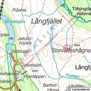 Click in the map to get a larger and more detailed map!! |
|