
Provinces
Blekinge
Bohuslän
Dalarna
Dalsland
Gotland
Halland
Lappland
Närke
Skĺne
Smĺland
Södermanland
Uppland
Värmland
Västergötland
Västmanland
Öland
Östergötland
Counties
Other stuff
Home
| Närke: Tomasbodahöjden - 298 m | |
|---|---|
|
Location: NW of Örebro Coordinates: N 59°23.046' E 14°58.325' Exact height: 298 m Hiking: Class 1 (What's this?) Hiking distance: 6.6 km round trip, on trail and on road Elevation gain: 60 m Kartor: Topographic: 10F NV Road map: Any road map All maps from Lantmäteriet |
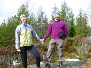 Click in the picture to see more photos. |
Approach:
From the Ekersvägen intersection at Rt E18/E20 in Örebro, drive towards Närkes Kil. Pass the sideroad to Frösvidal after 6.5 km. Närkes Kil is passed at 10.8 km. Turn left, to Bocksboda, at 11.9 km. The paved road becomes gravel at 17.4 km. There is a parking at the trailhead in Getingedalen at 20.3 km. Visitor's information and maps are available at the parking.Route: Hike south on the Bergslag's Trail. Starting on a gravel road and then through the woods. There are left-overs from art-work along the trail to the Kilsberg's Hut. The art was made during an artist's convention from material found in nature. E.g. a collection of pine tree cones stored between two branches in a tree, ten feet above ground; Branches from birch hanging from ropes between two trees; The silhouette of two fish cut in stones on the trail by a stonemason.Other: Close to L Dammsjön is the Trolldalen nature preserve (the Gnome valley). The preserve is worth a detour and is reached by a spur trial about 1 km south of the Kilsberg's Hut. | |
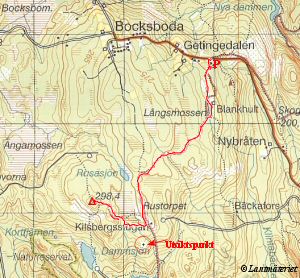 Click in the map to get a larger map! |
|