
Provinces
Blekinge
Bohuslðn
Dalarna
Dalsland
Gotland
Halland
Lappland
Nðrke
SkÍne
SmÍland
S—dermanland
Uppland
Vðrmland
Vðsterg—tland
Vðstmanland
øland
østerg—tland
Counties
Other stuff
Home
| Vðrmland: Granberget - 701 m | |
|---|---|
|
Location: E H—ljes in N Vðrmland Coordinates: N 60°53.848 E 12°44.523' Exact height: 701 m Hiking: Class 1 (What's this?) Hiking distance: 8.2 km round trip Elevation gain: Approx. 200 m Map(s): Topographic: 14C SO Road map: Any road map All maps from Lantmðteriet |
We haven't been to Granberget sofar and we are happy and thankful receivers, should anyone want to submit information. |
Approach:
Drive Rt 62 South from H—ljes, about 12 km, to Kðrrbackstrand. Turn left, N, towards Spjutbergssðtern. Keep right after about 3.5 km and continue 4.5 km to a T intersection. Keep left and then right after about 400 m. Continue uphill and approach yet another intersection after 900 m. Keep left and continue 400 m to next intersection and park.Route: The Vðrmlandsleden hiking trail cross the right branch of the road 100 m from the intersection. Follow the trail to the left for about 4 km to the summit of Granberget. A lookout tower is situated on the summit. | |
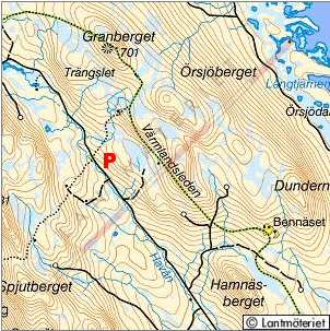 Click in the map to get a larger map!! |
|