Highpointing in Sweden, Logo - Helagsfjället


   Provinces
     Blekinge   
     Bohuslän   
     Dalarna   
     Dalsland   
     Gotland   
     Halland   
     Lappland   
     Närke   
     Skåne   
     Småland   
     Södermanland   
     Uppland   
     Värmland   
     Västergötland   
     Västmanland   
     Öland   
     Östergötland   

   Counties

   Other stuff

   Home 150 pixels wide dummy
Västergötland: Galtåsen - 362 m
Location: East of Ulricehamn
Coordinates: N 57°47.057'   E 13°33.022'
Exact height: 362 m
Hiking: Class 1 (What's this?)
Hiking distance: < 1.0 km round trip
Elevation gain: ~20 m
Maps:
  Topographic: 7D SV
  Road map: Road atlas for Västergötland

All maps from Lantmäteriet
Province Highpoint of Västergötland and County Highpoint of Västra Götaland
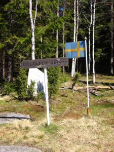
Click in the image to get a larger photo!
Approach:
Alternative 1, from the West:
Drive east on Rt 40, 7.5 km from the intersection between Rt 40 and Rt 46 in Ulricehamn. Turn right, S, to Kinnared in the Kinnared & Hössna intersection.

Alternative 2, from the East:
From the Gullered intersection on Rt 40, drive west 3.3 km and turn left, S, to Kinnared in the Kinnared & Hössna intersection.

Common:
Continue 1.8 km to Kinnared and turn left, E, to Galtåsen according to the orange sign at the right side of the road. Keep left after 700 m, and continue 500 m to the next intersection where another sign points to the left. Park in the intersection without blocking for other vehicles.
Route:
Follow the marked trail on the road in direction northeast. The trail turns right, off the road and into the woods, after about 250 m. Continue following the orange markers about 200 m to the highpoint. There is a triangle marker on the summit and also a picknick table and a Swedish flag in sheet metal.
Other:
We visited in May 2005 and there are still a lot of fallen trees after the winter storm.

A hiking trail with orange markers passes Galtåsen, the Galtåsen trail that is described on the web page of Ulricehamn community.

Topo map, Galtåsen in the Province of Västergötland and County of Västra Götaland
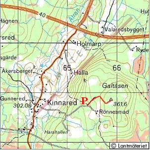
Click in the map to get a larger map!
webmaster@sverigestak.org
Last modified: Sun Jun 19 22:08:16 W. Europe Daylight Time 2005