
Provinces
Blekinge
Bohuslän
Dalarna
Dalsland
Gotland
Halland
Lappland
Närke
Skĺne
Smĺland
Södermanland
Uppland
Värmland
Västergötland
Västmanland
Öland
Östergötland
Counties
Other stuff
Home
| Halland: Högalteknall - 226 m | |
|---|---|
|
Location: Southwest of Vĺxtorp Coordinates: N 56°22.534' E 13°02.412' Exact height: 226 m Hiking: Class 1 (What's this?) Hiking distance: 0.4 km roundtrip Elevation gain: < 10 m Maps: Topographic: 4C SO Halmstad Road map: Any road map All maps from Lantmäteriet |
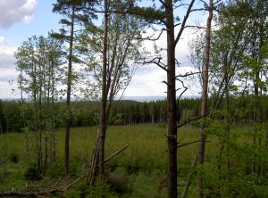 Click in the picture to see more pictures. |
Approach:
Drive from Vĺxtorp to Vindrarp and turn left (east). Pass the first road to the right and turn into the second road, about 800 m from Vindrarp. Continue uphill for about 2.8 km to the summit of the road. Park next to the radio tower to the right.Route: The highpoint is about 200 m on the left (east) side of the road, in the woods on a small hill. There should be a triangle mark on the summit.Other: The highpoint is situated on some kind of military ground that is not allowed to enter nor allowed to take pictures of. We don't know whether the triangle mark is there but we took a picture of the sign. |
|
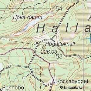 Click in the map to get a larger map!! |
|