
Provinces
Blekinge
Bohuslän
Dalarna
Dalsland
Gotland
Halland
Lappland
Närke
Skĺne
Smĺland
Södermanland
Uppland
Värmland
Västergötland
Västmanland
Öland
Östergötland
Counties
Other stuff
Home
| Gotland: Lojstahajd - 82 m | |
|---|---|
|
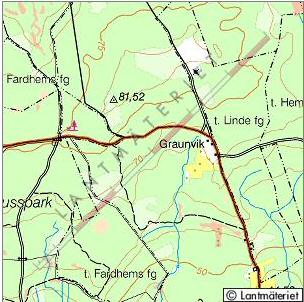
Location: NW of Lojsta on southern Gotland Coordinates: N 57°19.929' E 18°20.226' Exact height: 82 m Hiking: Class 1 (What's this?) Hiking distance: 0.5 km round trip Elevation gain: 5 m Maps: Topographic: 6J SV Road map: Road atlas for Gotland All maps from Lantmäteriet |
We haven't been to Lojstahajd sofar. We are happy and thankful receivers, should anyone want to submit information. |
Approach:
Drive 5 km NW from Rt 142 in Lojsta. Pass Graunvik and turn right shortly after. Park along the road after about 400 m.Route: The highpoint, Lojstahajd, is about 200 m to the right of the road. The should be a triangle mark on the summit. |
|
 Click in the map to get a larger map! |
|