
Provinces
Blekinge
Bohuslðn
Dalarna
Dalsland
Gotland
Halland
Lappland
Nðrke
SkÍne
SmÍland
S—dermanland
Uppland
Vðrmland
Vðsterg—tland
Vðstmanland
øland
østerg—tland
Counties
Other stuff
Home
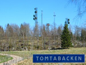
| SmÍland: Tomtabacken - 377 m | |
|---|---|
|
Location: South of Malmbðck Coordinates: N 57°30.019' E 14°28.205' Exact height: 377 m Hiking: Class 1 (What's this?) Hiking distance: 1.0 km round trip Elevation gain: 20 m Maps: Topographic: 6E NV Nðssj— Road map: Any road map All maps from Lantmðteriet |
 Click in the picture to see more pictures. |
Approach:
Drive south from the railroad intersection in the center of Malmbðck (southwest of Nðssj—). There is a sign to Tomtabacken. Pass the road to Hok after 1 km and the village of Estenstorp after 7.3 km. Park in the Tomtabacken parking area in St. ékerhult, 9.2 km from Malmbðck.Route: Hike east from the parking and follow a spur trail to the summit. There is a watch tower and several antennas on the summit. There should be a triangle marker on the summit. It may be hidden by the concrete fundation below the tower. |
|
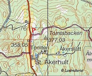 Click in the map to get a larger map!! |
|