
Provinces
Blekinge
Bohuslän
Dalarna
Dalsland
Gotland
Halland
Lappland
Närke
Skĺne
Smĺland
Södermanland
Uppland
Värmland
Västergötland
Västmanland
Öland
Östergötland
Counties
Other stuff
Home
| Uppland: Upplandsberget (Tallmossen) 118 m | |
|---|---|
|
Location: ENE Heby Coordinates: N 59°58.266 ' E 17°05.291' Exact height: 118 m Hiking: Class 1 (What's this?) Hiking distance: 3.0 km round trip on dirt road and on trail Elevation gain: < 30 m Kartor: Topographic: 12H SV + 11H NV Road map: Any road map All maps from Lantmäteriet |
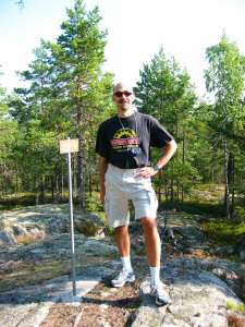 Click in the picture to see more photos. |
Approach:
From Rt 72 at the Inn in central Heby, drive North towards Heby Center. Pass the railroad after about 0.7 km and turn right to Huddunge. Turn right again after 3.1 km, to Molnebo (3.8 km from Rt 72) and in Molnebo, another right to Östfora (6.6 km). Pass the border to Uppsala County 15.3 km from Rt 72 in Heby. The road noow follows lake Tarmlĺngen. Turn right on a gravel road to Asplund at 17.3 km. Drive about 1 km to a four way intersection (18.4 km). Park off the road.Route: Follow N Sörviksvägen west to a three way intersection. Take the left road and continue about about 100 m to a sign "Upplandsberget", to the right of the road. Follow the trail from the sign about 300 m to the summit. There is a sign on the summit that IF Thor in Uppsala placed there in 1999. | |
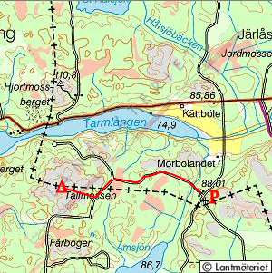 Click in the map to get a larger map! |
|